
Looking across The Bay from the memorial to the cockle pickers who died in February 2004
From Sunderland Point on the estuary of the River Lune in north Lancashire to Walney Island by Barrow-in-Furness, the coastline of Morecambe Bay meanders and loops for around 60 miles, encompassing a large intertidal area and home to many creatures. The tidal range of up to 10 metres transforms the view twice a day, revealing sand banks, skears [banks of stones] and channels. Towns and villages fit in among the sandy beaches, salt marsh, shingle and crags. Everywhere you have a view of sea and sand and a backdrop of hills, either the Lake District fells or the distinctive limestone hills to the south.
From our home in Morecambe we set out to walk around The Bay in a series of day trips over the years, usually using buses and trains. This post covers Sunderland Point to the Cross Bay walk from Arnside to Grange-over-Sands.
Sunderland Point to Middleton
The number five bus takes us to the village of Overton, south of Morecambe and the closest we can get to Sunderland Point by public transport. From Overton we like to climb up to the trig point first for the view across the causeway to the village. The tarmac tidal causeway travels about 2.5km over muddy channels and salt marsh to the village of Sunderland Point. This can be accessed at low tide but is covered by water at most high tides. You can check the tides and access here. Cars can also park at Potts Corner and you can walk to Sunderland Point from there.
I look and listen for birds as we approach the boats and attractive terraces of 18th century houses that make up Sunderland Point, at the southerly end of Morecambe Bay. Each house has a history dating back to the days when this was a busy port. The last house, The Old Hall, is the oldest in the village, built in 1683 for the Pearsons, merchants who traded in cloth, coal and felt hats in the colonies in return for tobacco.
Stumbling along the stony shore you will notice Plover Scar lighthouse and Glasson Dock across the Lune. If the weather is clear you might see Blackpool Tower. Turning around the point to head north you soon reach the Bird Hide and Horizon Line Chamber, an stone domed installation. Go inside and see an inverted view of the Bay. Just beyond stop for a moment at the grave that is thought to commemorate an enslaved black African, who died in 1736, shortly after his arrival here.
You can take the path to cross back to the village here, but to walk more of the coast we continue along the track to Potts Corner. The shoreline always throws up driftwood and shells and we often see egrets feeding in the winding salt marsh channels. Holiday parks take up the coast for a short distance and we head inland on the narrow lane that meanders back to Middleton where we pick up the next bus back to Morecambe.
Heysham to Morecambe
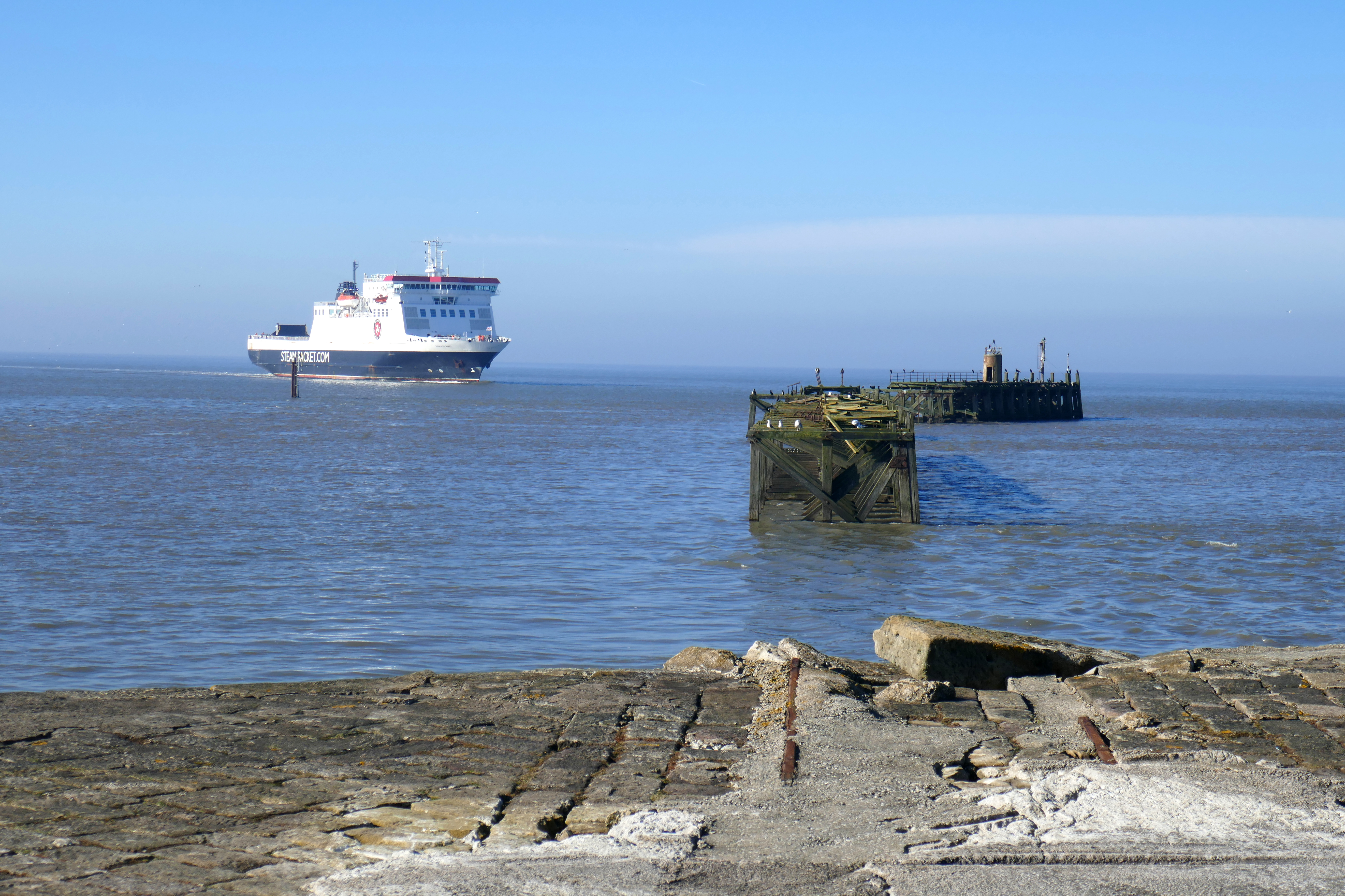
Using the regular bus to Heysham Towers we make our way towards Heysham Port and turn down Moneyclose Lane towards Ocean Edge Caravan Park. After 350m you can turn right off the lane and pick up the paths in Heysham Nature Reserve. These paths are popular with dog walkers. Follow them around the two nuclear power stations to the coast and turn right on to an airy concrete walkway. This stretches about 1km to the lighthouse at the mouth of Heysham harbour. At high tide on a fine day there is no place quite like this; the sea is at your feet on your left while the nuclear power station hums to your right. We were lucky to catch the Isle of Man ferry coming in on our first visit and waved at the captain, who returned the greeting.
Retracing our steps we skirted around Heysham Harbour on the roads to rejoin the shore at Half Moon Bay. The Ship sculpture here is a stunning piece, with two opposing figures on the ends of an outline of a ship’s hull. Paths wind around the grassy headland covered in gorse that rises to the ruins of St Patrick’s Chapel and the much photographed rock-hewn graves.
The paths take you back to Heysham by the picturesque St Peter’s Church, which dates from the Saxons. The view from the churchyard over Morecambe Bay is breathtaking and, if the church is open, pop in to see the Viking gravestone. The nearby Royal is a cosy pub and perfect for refreshments before joining the promenade and walking to the stretch to Morecambe.
Morecambe to Carnforth
This is a favourite walk that we can easily do from home. We take the bus to Carnforth and walk back along the coastal path, beginning along the mouth of the River Keer and then skirting the salt marsh to Red Bank Farm. In winter, depending on the tide, there will be plenty of birds including oystercatchers and lapwing.
Just beyond Red Bank Farm is the moving memorial to the cockle pickers who died in Morecambe Bay in February 2004, a reminder of how dangerous the tides can be. Morecambe Bay’s tides move in with speed, along channels and around sand banks and skears in unpredicatable ways. Add river channels and quicksands and you have sands that deserve respect.
From the grassy bank lined with wind-blown trees, the path returns to the shore and can be rough with large pebbles, but it is hard to get lost, all you need to do is keep the sea by your side. There are also lots of places to stop for refreshments. Bay View Garden Centre near Bolton-le-Sands is hard to beat for the view and they serve good food. Red Bank Farm has a cosy cafe, there is a cafe at Hest Bank by the railway crossing and another as you leave the stony shore before the promenade and Morecambe. This walk also has plenty of benches for outdoor picnics.
Reaching the Promenade in Morecambe you will pass the beautiful Venus and Cupid statue. I always stop and admire this statue, finding new meanings each time.

Carnforth to Silverdale
Both Carnforth and Silverdale are on the train line that skirts Morecambe Bay, making this linear walk easy to plan.
From Carnforth you can head straight up Warton Crag but an interesting diversion awaits on the coast beyond the Warton Stock Car Club circuit. Take the road towards Warton, turning off after going under one railway bridge, after another railway bridge you cross the River Keer. Follow the tarmac lane by the railway line and at the end turn left and walk on tracks around the farm and the race circuit, a busy and noisy place on race days but usually quiet. Beyond here you will find an unusual coastline formed by slag heaps from the local iron works that operated from the 19th century up until 1929. There were once five blast furnaces working here and these coastline peaks and iron-red rocks are what remain, now beginning to blend in with the surrounding salt marsh. Explore as much or as little as you wish.
Retracing our steps, we continue through Warton village to climb Warton Crag. If you want refreshments there are a couple of pubs in Warton and a brewery that sells their own beer and food.
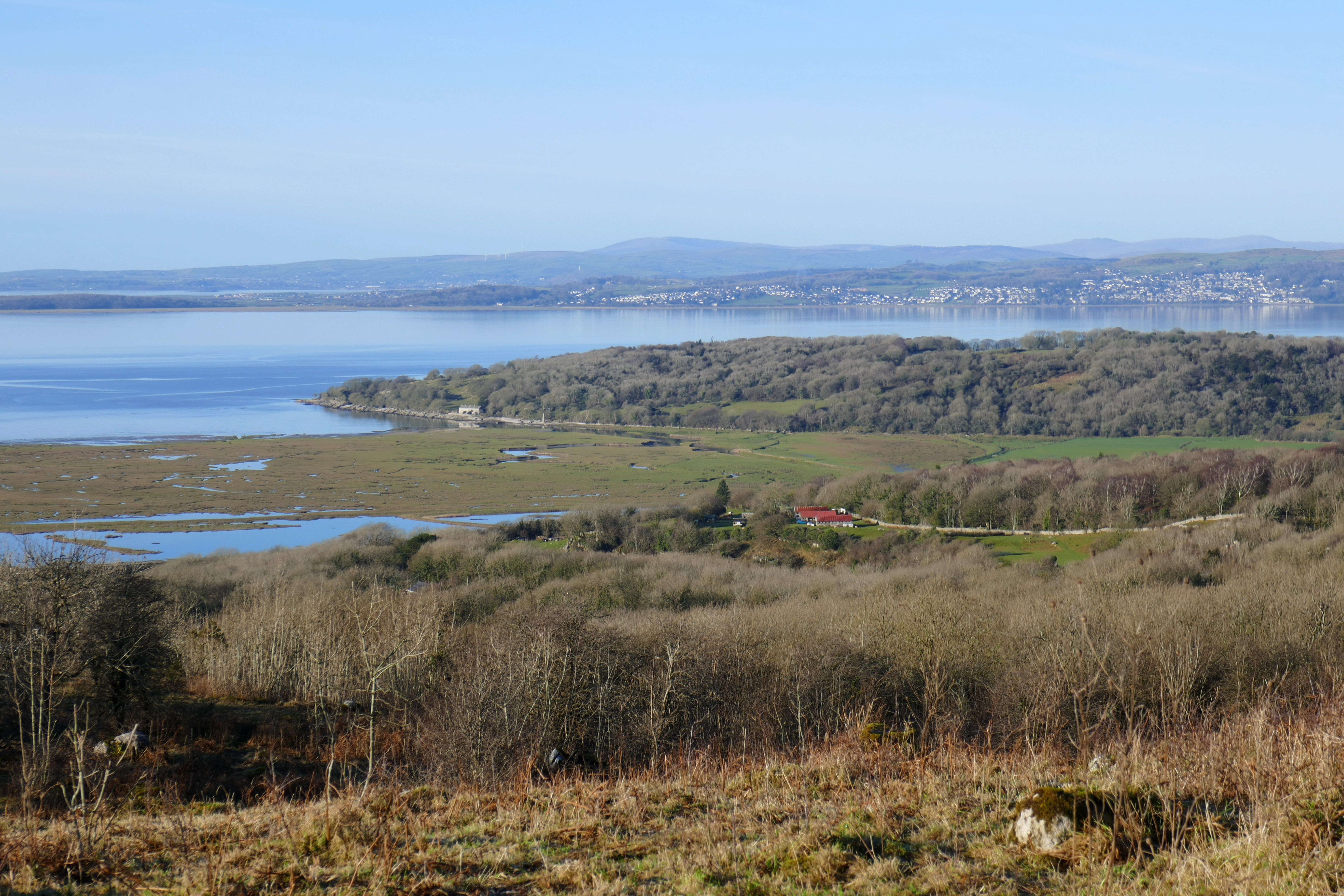
There are many ways up Warton Crag and you can choose your own. We like the stony path that is by the picnic site at the top of Coach Road. This takes you steeply through the woodland to a bridleway and possibly drovers road known as Occupation Road. Leave the track on one of the paths to the left to reach the top of Warton Crag. There isn’t a view from the trig point but just nearby you will stand on a limestone crag and have Morecambe Bay laid at your feet, from Heysham and the distinctive power stations to the south to the outline of Barrow-in-Furness across the Bay.
Warton Crag is criss-crossed by footpaths and one will take you back to Occupation Road and turning left you will reach a lane. Turn right to Crag Foot and there turn right and right again for Silverdale railway station opposite the golf club.
Silverdale to Arnside
Once again the Furness Line railway helps linear walkers. Silverdale railway station is some distance from the village but the walk there is superb. Dodging the traffic for a short distance going left from the station, you can pick up a woodland path down to Jenny Brown’s Point. Check the tides, as parts of this path can be under water when the tide is very high. If necessary you can take the lanes to the point.
Jenny Brown’s Point is a special place for many. There is a sense of space on the point, with woodland behind you and Morecambe Bay spread out before you. A tall chimney stands on the shore and channels wind through the sands at low tide. The chimney is probably the remnant of a metal furnace here in the 18th century. Morecambe Bay Partnership have an excellent booklet about the history of this area that you can download here.
From Jenny Brown’s Point paths and a lane wind round the coast to Silverdale. The Silverdale Hotel is an excellent spot for refreshments but don’t linger too long as this is a 12km walk and there are plenty of highlights to come.
Just after the hotel pick up a path across a meadow that takes you to The Cove, another picturesque spot. From here you’ll need to take the road past the caravan site, but it is fairly quiet. There is a path from the Holgates site entrance if you prefer and there is a cafe here too. The road to two more caravan sites on your left gives you access to the coast path around Arnside Knott.
This is a stretch of coastline as delightful as any you will find. The woodland hugs the craggy coast and the sounds of the sea mingle with woodland birds. You will walk above occasional sandy and pebbly bays with views across to Grange-over-Sands. If you’re lucky you will feel as if you have this stretch of coast to yourself and you’ll find a spot to linger.
Turning the corner to the Kent Estuary you cross a boggy area on a good track and then follow the shore to Arnside’s front. Arnside is a popular village with visitors and there are plenty of pubs and cafes.
The Cross Bay Walk
This unique walk isn’t something you can do on your own but it is the best way of understanding what Morecambe Bay is all about. A guided walk across the sands is a safe way to enjoy this experience, so check out the dates for the guided walks and book one.
Using the train makes lots of sense for this walk, as you start in Arnside and finish in Grange-0ver-Sands. The length of the walk varies depending on the tides, quick sands and river channel and the number of fellow walkers depends on the weather and the number of charities involved. We have completed this walk three times now and I have enjoyed it every time.
The walk does involve paddling through the River Kent. It is fun, exhilarating and at moments I stop and look around with awe. Land can seem a distant apparition from the midle of Morecambe Bay and I have a sense of being lost in sand and water. Before the railways this route was used frequently and I often think of the bravery of those travellers from the past crossing to head north or south. Fortunately, the Kings guide, Michael Wilson, is experienced and I always feel in safe hands.

With thanks to The Gathering Tide, A Journey Around the Edgelands of Morecambe Bay by Karen Lloyd.