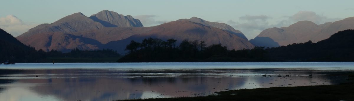
Tal-y-mignedd Campsite in the Nantlle Valley is a campsite that is made for the word nestling. Tucked away between steep hills on the edge of the Eryri National Park [Snowdonia] in North Wales, this is a place to find tranquility, fabulous hiking and, maybe surprisingly, good coffee.
The Campsite
Pitches – At Tal-y-mignedd, the camping is divided over a number of fields from large to small enough for just a few tents. These are all either totally level or mostly level and all have open views. For campervans there are a few hardstanding pitches with electric hook up and some grass pitches with electric too. There is also plenty of room for non-electric pitches for tents and ‘vans on grass.
Facilities – There is one facilities block with male and female showers and toilets, an accessible bathroom and a kitchen with sinks for washing up, a microwave, hob, kettle and fridge/freezer and washing machine and dryer. There is also a second campers kitchen which wasn’t open when we were there. There is a chemical toilet disposal point and fresh water taps. Everything was kept clean and tidy. A pleasant surprise in a valley that has little in the way of phone signal was good and free wi-fi.
Access – The B4418 between Rhyd-Ddu and Nantlle is single-track in places. You either have to drive three miles on this quiet narrow road from the Beddgelert to Caernarfon road or around two miles from the village of Nantlle.
The campsite wasn’t busy when we were staying there. It was mid-week and May and only three or four other pitches were in use. This didn’t put any strain on the facilities but a stay here would be a livelier experience during a busy summer weekend.
Reception is in the farmhouse and the family were always friendly and helpful. This is still a working farm and their vehicles drive up and down the track but this was never intrusive. Sheep sometimes find themselves on the camping field and the sound of birdsong is interupted by cattle!
We paid £27/night with electric hook up and it is £20/night without. This seemed good value for hot showers and fabulous views.
Things to do
The campsite sits on the Snowdonia Slate Trail. This 83-mile long circular route starts and ends in Bangor and visits sites associated with the slate industry of North Wales and takes walkers through forests, by lakes and into villages. The section along the Nantlle Valley is fairly level and reasonably well signed. From Tal-y-Mignedd we picked the trail up in both directions.
Walking East – Heading towards the peak of Yr Wyddfa [Snowdon], we joined the narrow lane for a short distance, through the hamlet of Drws y Coed where we left the road and followed an increasingly damp path past an unused dam towards woods. A cuckoo called from across the valley and making our way around the craggy Clogwyn Y Garreg we had views of Yr Wyddfa. You could extend this walk and make a day of it with a rest at the pub in Rhyd-Ddu.
Amazing sunsets – The valley is aligned pretty much east-west and watching the light soften as the sun goes down is special.
Walking West – We also followed the Snowdonia Slate Trail along the valley bottom into Nantlle village and walked back along the lane, making a circular walk. The farm track passes a lake, Llyn Nantlle Uchaf, before reaching the village. At one time there were 40 slate quarries in the Nantlle valley and the village developed at the end of the 18th century to serve this industry, many of the quarrymen coming from Ynys Môn [Anglesey] and Arfon [the mainland of Wales facing Ynys Môn. For more about the history of Nantlle see the Dyffryn Nantlle website.
Drinking good coffee – In Nantlle we visited Poblado Coffi. In a unit in the old quarrymen’s barracks, coffee experts roast and blend beans. All the beans are sourced from sustainable coffee growers and they have strong relationships with these growers and pay a fair price for the coffee. We sat in the courtyard tasting the delicious coffee of the day, along with a slice of ginger flapjack and left with a couple of bags of coffee in the rucksack. If you find yourself anywhere near this gem, take the time to visit.
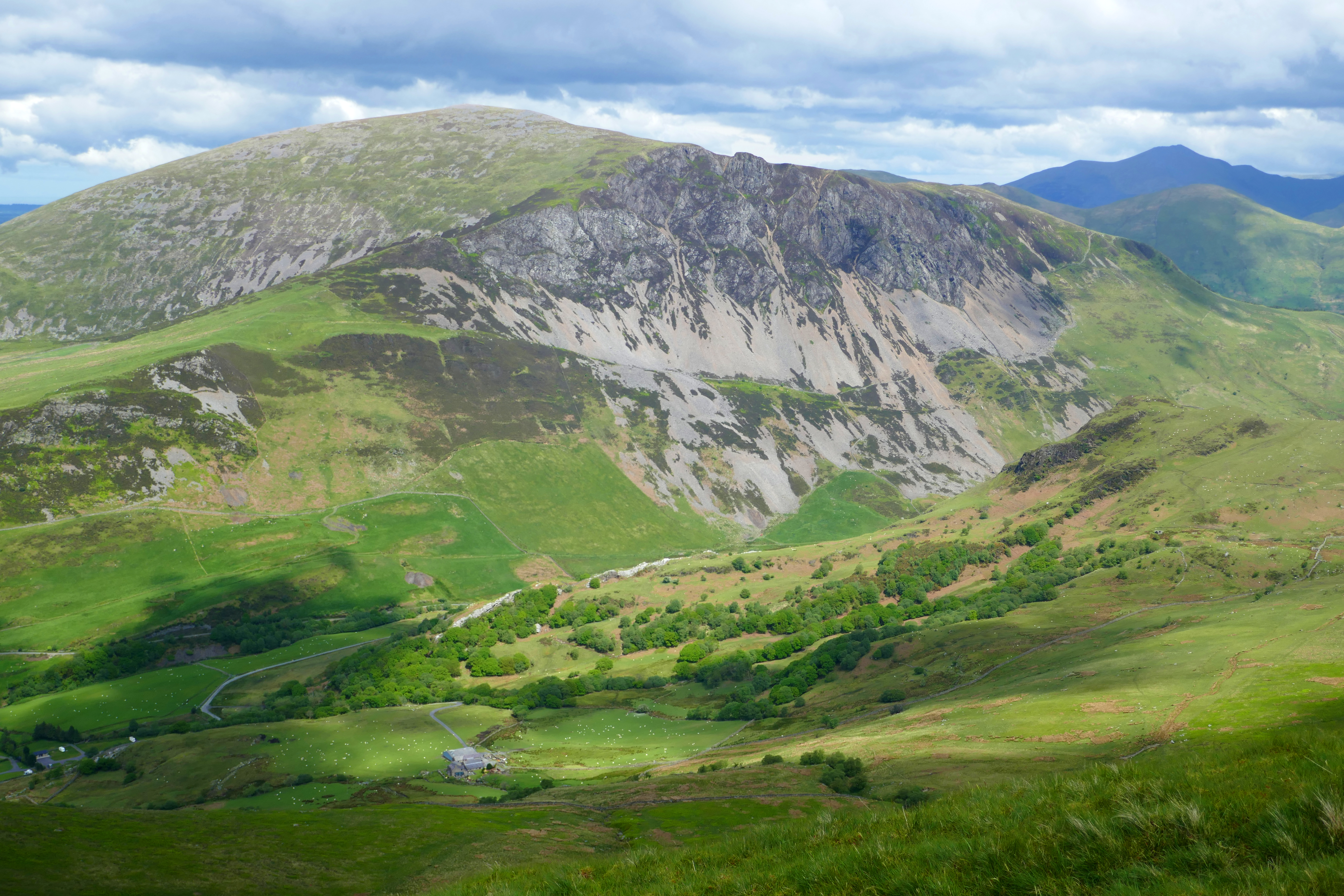
Walking up – We couldn’t resist climbing the hill that the farm shares its name with. This is a relentless steep climb but worth it for the views over the mountains, including Yr Wyddfa and to the sea. The first section is on a zig-zag track that climbs through sweet-smelling bluebells in May. The hill is only 653m high but punches above its weight and the rocky summit has a tall obelisk that you can see from the valley. Once at the top, fit and experienced walkers will continue along the stunning Nantlle Ridge for a longer walk and in warmer weather we would probably have done the same.
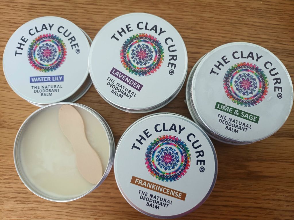
Reducing plastic is important to me but so is finding things that do what they say on the tin. The Clay Cure natural deodorant balm covers both these bases, it comes in a tin and does what the label says!
My search for a deodorant that is effective and easy to use is one that has lasted decades. I have tried rock-like crystal deoderants that had little impact; I have experimented with deodorant bars from Lush [one of my favourite companies] but found them messy and ineffective [but they do work for others] and I have tried doing without. The latter means I end up washing my clothes more often which uses more washing powder [in a cardboard box] and wears out my clothes more quickly, so isn’t a perfect solution.
So when I purchased a tin of The Clay Cure’s deodorant balm a couple of years ago, I wasn’t very hopeful that this would be the wonder product it is. Now I wouldn’t go anywhere without it.
For women and men, the deodorant balm comes in a small metal tin, not quite 7cm in diameter and around 2.5cm tall. It has a screw-on lid. Inside is a solid but soft deodorant, about the consistency of fridge-hardened butter [but it is vegan] [it is often softer in summer when the weather is warm]. The tin comes with a flat wooden spoon, familiar from tubs of ice-cream. You use this to scoop up a pea-size ball of the balm. Rolling this between your fingers warms and softens the balm and it is then easy to rub it in under your armpits. It disappears immediately, there is no waiting for it to dry, it isn’t greasy and it doesn’t stain your clothes.
I now buy in bulk from The Clay Cure website and, if you sign up for their newsletter, you will be notified when they have offers. There are currently eight different perfumes and a neutral deodorant. I like all of them, particularly the lavender and the lime and sage but you will have your favourite. You can find them on sale in other retailers such as wholefood shops and large farm shops.
If you buy two from their website, they are currently £8 each. I haven’t tracked how long they last but it spreads into months. There is no waste due to being packaged in a tin. This means you can get at every single bit of the balm. You are also left with a tin which is useful for storing all sorts of stuff from pins to peanuts or screws to sweets. Adding up all the plus points, this deodorant balm doesn’t feel like an extravagance.
Other easy wins in my aim to reduce our plastic footprint and stay reasonably clean and fresh smelling include solid shampoo, rather than bottles. We also always use bars of soap, rather than shower gel or liquid soap.
As usual, I have not been paid or even given any free products [I wish] to write this review. I share information about products I have found and enjoy using.
The Derbyshire market town of Buxton is famous for water; having the highest market place and its graciously curved Georgian crescent. We have visited many times and find it perfect for two campervanners who like hiking. Buxton has a number of campsites [see below] and does offer sights for those who don’t want to spend the day in the surrounding countryside. But if, like us, you enjoy a warm day in the great outdoors, below are five of my favourite walks for five days camping in Buxton.
The distances on the walks below are approximate and are based on walking from the Caravan and Motorhome Club’s Buxton site. I haven’t given step-by-step directions but the paths in this popular part of the country are well-walked and I hope that you can pick up our route [or make up your own] from an OS map.
Day One – Exploring Buxton [at least 7kms]
Buxton’s heritage trail leaflet will help you make the most of a stroll around the town. But first you have to walk to the town centre and leaving the campsite, you will immediately be distracted by the delightful paths through Grin Low Woods and to Solomon’s Temple.
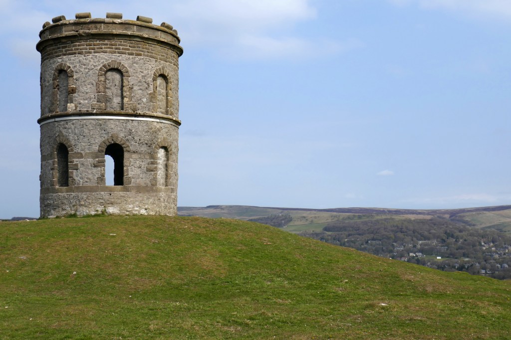
Solomon’s Temple is a perfect introduction to Buxton. Climb the winding staircase of the hilltop tower and Buxton is laid before you, clustered around the dominating slate-grey Devonshire Dome.
Having taken in the view, we head downhill on the woodland paths with occasional wooden sculptures and reaching the streets by Poole’s Cavern. If you’ve never visited you might want to dally and explore this underground cavern.
We like to amble through the town’s restored Pavilion Gardens. There might be an art fair being held in the Octagon Hall or we will idly watch the ducks and look hopefully for chicks on the lake. I also like to admire the preserved tree trunk sculpted into figures and animals that stands in the park. The water-carrying figure of Arnemetia is a reminder that in Roman times Buxton was named Aquae Arnemetiae after this Romano-British goddess.
Our next stop is The Crescent, a Georgian grade one listed masterpiece and the pride of Buxton, recently restored as a luxury hotel. The gracious symmetrical curve of the stone building, the ground floor colonnade and fountains playing at the front are stunning. Opposite is St Anne’s Well which is decorated with flowers in the annual well dressing, a tradition followed in many Derbyshire villages and towns. The Pump Room has a tap and souvenir glass bottles, and I did once fill one with Buxton spa water to taste the lukewarm mineral-rich water. It is an aquired taste!
Buxton’s spring water emerges from the ground at around 28°C and has been exploited since the Romans, who built a bath and threw coins into the spring for luck. In the 16th century visitors took the water and in the Georgian era the Duke of Devonshire developed a spa resort. A ‘Well Woman’ was appointed to care for the well and tourists, a post that continued into the 20th century.
After all this strolling, we are ready to sit and there are plenty of cafes and tearooms in Buxton. Later we will walk over for a close-up of The Devonshire Dome. This building has an interesting history and has been used as stables, a hospital and is now a University. Finally, we will climb the paths up The Slopes to the upper part of Buxton, where the town’s oldest buildings surround England’s highest market place and from there head back to the campsite.
Day Two – Goyt Valley and Errwood Reservoir [about 14kms]
After the streets of Buxton, day two is a contrasting and challenging hike over moorland. A map will be essential to find your way around these moors but you will be rewarded with the sounds of lapwings and curlews and buckets of fresh air.
From the A53 near the campsite, we picked up Bishop’s Lane and climbed the hillside until a path took us to the disused railway line. Views over the two reservoirs in Goyt Valley will open out before you.
Reaching a lane, we descend to the shores of Errwood Reservoir. From here we chose paths that climb through the trees to the ruins of Errwood Hall. We are walking through what was once the grand ornamental garden where fountains played and the Grimshawe family, who lived here, relaxed on the lawns. Demolished in 1934 after the last of the Grimeshawes died, Errwood Hall was originally a dressed-stone building with a tower above an impressive entrance and rooms packed with fine furniture and art works. In those days the hall enjoyed views over the valley but is now surrounded by trees and rhododendrons. For me, the ruins have always retained a sense of romance tinged with loss but on our last visit it seemed particularly woebegone. The site deserves a little more care and I was disappointed there isn’t even an interpretation board to show what used to be here. However, there is an app and more information here.
From the hall we headed uphill finding the small circular St Joseph’s shrine that huddles in a hollow with pine trees. Dedicated to Dolores, a Spanish companion to Jessie Grimeshawe in 1889, the shrine has an elaborate altar of Spanish tiles and there are often fresh flowers. As we descended the moorland back to the reservoir a grey cloud threatened rain and we followed a circling buzzard towards the trees and shelter but the storm never arrived.
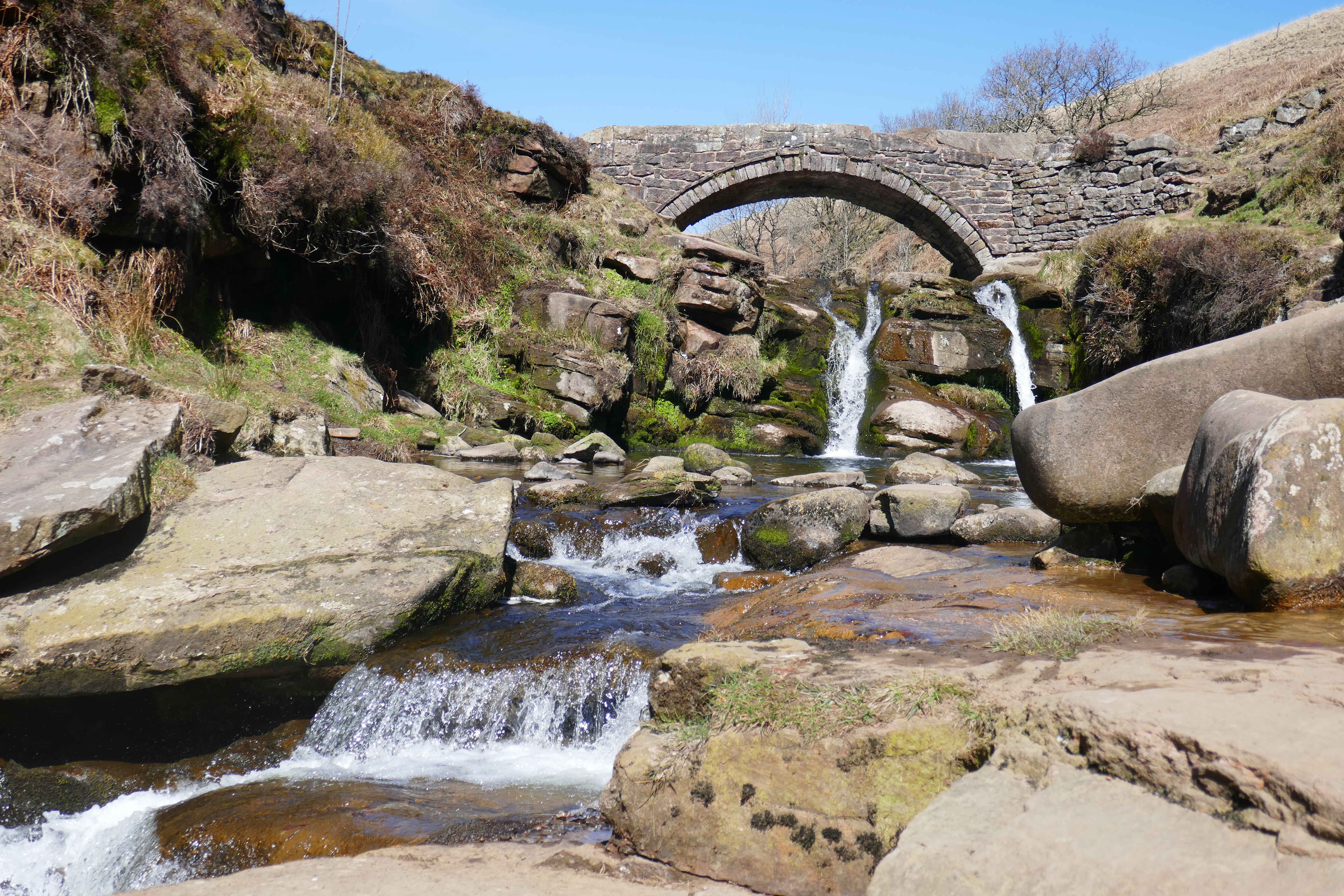
Walking south along the valley beyond Errwood Reservoir we crossed the old packhorse bridge and picked up a path over the moorland and back to Buxton. More walks in the Goyt Valley and its history can be found here.
Day Three – Three Shires Head [Around 17kms]
If you only have time for one day of hiking around Buxton, make it this one! The walk begins on the Dane Valley Way and you soon leave the traffic behind as you cross Axe Edge Moor, an expanse of moorland that holds the headwaters of four rivers, the Manifold, Dane, Wye and Goyt. Despite the warm weather, it was just us on this path enjoying the gurgling streams and passing a few isolated farms and old mine workings.
At Three Shires Head, where Staffordshire, Derbyshire and Cheshire meet, we joined the throng. These falls are a popular picnic and wild swimming spot. Sitting by the waterfalls I slipped off my shoes and dipped my toes in the gaspingly-cold water of the River Dane. As I dried my tingling feet I watched the hardy woman swimming in Pannier’s Pool in admiration.
Climbing up the hillside to Flash, a sheltered lane alive with butterflies took us to Flash Bar Stores where we devoured two of their delicious homemade vegetable pies at an outdoor table. A popular halt for cyclists, we chatted to a young man who was fuelling up having cycled from the West Midlands and was surprised how hilly the Peak District was!
Exuberant skylarks sang as we crossed the fields, criss-crossed by stone walls, below Flash. Multitudes of signs heralded the Health and Safety Executives huge Science and Research Centre. We skirted the buildings on the public footpath and picked up a lane that took us back to the road below the campsite.
Day Four – Five Dales from Tideswell [13kms]
On a perfect spring day we drove the short distance to the car park in Tideswell Dale. This perfect Derbyshire walk took us along, in and out of five dales.
We began in Tideswell Dale where a winding stream lined with bright yellow celandine wound beside us and rock cress hung from the limestone cliffs. Ash trees grow here but many have been chopped down due to ash dieback, a destructive fungal disease.
Miller’s Dale, not surprisingly, is home to many disused mills along the River Wye, often now converted to housing. I was concentrating on looking along the river for kingfishers. I didn’t see a kingfisher but a birdwatching couple pointed out a peregrine they had spotted on the skyline above us.
At Cressbrook we sat by the millpond watching the climbers on the crags and a pair of tufted ducks. The ducks dived into the shallow water to feed, stirring up the silt into billowing muddy streaks so that we could watch their underwater progress. Cressbrook Dale is thickly wooded with pungent wild garlic and carpets of soft green moss covering the dry stone walls.
The landscape opened out as we reached the short Tansley Dale where we found cowslips just coming into flower among the grasses. We climbed up to the patchwork of walled fields above the dales where lambs gambolled in the sunshine and the shallow Litton Dale led us back to the ‘van.
Day Five – Five Wells & Deep Dale walk (13kms)
In more sunshine, we walked through the wood to Buxton to catch a bus towards Bakewell. We hopped off near the village of Taddington and walked back to Buxton.
Our first stop was Five Wells Chambered Cairn. Here the stones that remain of a circular chambered cairn perch on high ground above the source of five springs. Although many of the stones have been taken, the two back-to-back chambers can be recognised. Descending to the village of Chelmorton we passed Bank Pit Spring, inexplicably and bizarrely known locally as Illy Willy Water.
The path into the wooded Deep Dale was steep but the sheltered dale was perfect for a lunch stop. As we ate, three sheep nose-to-tail went purposefully by on a lower path. When minutes later a fourth sheep appeared we assumed she was lagging behind and helpfully pointed in the right direction. Instead she came over and nudged my arm with her nose demanding food. We were eating more delicious pastries from Flash Bar and so there was no chance we would share!
The scenic uneven path along Deep Dale, over moss-covered stones and between trees, took us below the cave known as Thirst House before climbing up to King Sterndale and returning into Buxton under the 13 arches of Dukes Drive viaduct. Back in Grin Low Woods, we found a thick carpet of wood anemone and on the way back to the campsite picked up part of Buxton’s Ring of Trees Walk, a circular route through surrounding woodland.
Lime Tree Holiday Park – We have stayed here a few times. It is in a peaceful position just a short walk from Buxton.
Beech Croft Farm – this family-run site is between Buxton and Bakewell and in quiet countryside. Walk Five is near here.
Longnor Wood Camping – This adult-only site is near the village of Longnor. There is good hiking from the campsite and some cosy country pubs in the vicinity.